The Buhen fortress was most probably constructed during the rule of Senusret III in around 1860 BCE (12th Dynasty) of ancient Egypt. Senusret III conducted four campaigns into Kush and established a line of forts within signalling distance of one another; Buhen was the northernmost of these. Buhen fortress exemplified the culmination of Middle Kingdom defensive and administrative planning. Its design embodies the pragmatic concerns of military security while simultaneously expressing the ideological imperatives of Egyptian sovereignty.
The Kushites captured Buhen during the 13th Dynasty, and held it until Ahmose I recaptured it at the beginning of the 18th Dynasty. It was stormed and recaptured by indigenous forces at the end of Egypt's 20th Dynasty. The other forts built along the banks were Mirgissa, Shalfak, Uronarti, Askut, Dabenarti, Semna, and Kumma. The fortress at Buhen is now submerged under Lake Nasser as a result of the construction of the Aswan Dam in 1964 CE. Before the site was covered with water, it was excavated by a team led by Walter Bryan Emery.
The ancient fortress of Buhen, situated on the west bank of the Nile river near the Second Cataract in present-day Sudan, represents one of the most sophisticated examples of Middle Kingdom military architecture in ancient Egypt. Constructed during the reign of Senusret I of the Twelfth Dynasty, Buhen served not only as a strategic military outpost controlling trade routes into Nubia but also as a testament to the Egyptian state’s capacity for large-scale architectural and logistical coordination. Its architectural features reveal a deliberate synthesis of functional engineering, defensive innovation, and symbolic expression of Egyptian authority in the Nubian frontier.

circa 1800 BCE

Plan
The fortress itself extended more than 150 metres (490 feet) along the west bank of the Nile. It covered 13,000 square metres (140,000 sq ft), and had within its wall a small town laid out in a grid system. At its peak it probably had a population of around 3,500 people. The fortress also included the administration for the whole fortified region of the Second Cataract. Its fortifications included a moat three metres deep, drawbridges, bastions, buttresses, ramparts, battlements, loopholes, and a catapult. The walls of the fort were about 5 metres (16 feet) thick and 10 metres (33 feet) high.
The layout of Buhen reflects a highly organized and standardized approach to fortification design, which characterized Egypt’s Middle Kingdom expansion policy. Enclosed within massive mudbrick walls measuring approximately 5 meters in thickness and rising over 10 meters in height, the fortress extended for nearly 150 by 138 meters. The walls were reinforced with external bastions and inset buttresses that created a rhythmic façade, serving both structural and defensive purposes. A wide moat, hewn into the bedrock and likely filled with Nile water, encircled the fortress on its landward sides, effectively impeding direct assault and undermining operations. The entrance was strategically positioned along the northern wall, protected by a complex gate system incorporating multiple chambers, drawbridges, and guardhouses—an arrangement indicative of advanced military engineering.
Internally, the fortress was subdivided into distinct zones that accommodated administrative, residential, and storage functions. The central area contained the command quarters and barracks, while the periphery housed workshops, granaries, and temples. Excavations conducted by Walter B. Emery in the 1960s revealed evidence of a highly regulated spatial hierarchy, in which streets and buildings followed a rectilinear grid pattern—a feature rarely encountered in earlier Egyptian settlements. This orthogonal layout facilitated the efficient movement of troops and supplies while also reflecting the bureaucratic order characteristic of the Twelfth Dynasty’s state administration. Notably, the presence of granaries and large magazines suggests that Buhen functioned as a logistical hub, capable of sustaining extended military campaigns in Nubia.
Architecturally, Buhen demonstrates a fusion of Egyptian and local Nubian building traditions. While the overall plan and monumental scale conform to Egyptian models, the use of locally sourced sandstone for certain structural and decorative elements indicates adaptation to regional conditions. The defensive towers, positioned at regular intervals along the curtain wall, were designed with arrow slits and parapets, allowing for both close-quarters and ranged defense. These features reveal an understanding of siege warfare unprecedented in earlier Egyptian fortifications, suggesting that the builders of Buhen had engaged with or anticipated military technologies introduced from the Near East.
The symbolic dimension of Buhen’s architecture should not be overlooked. The fortress served as a visible manifestation of Egyptian hegemony, projecting state power deep into Nubian territory. The inclusion of a temple dedicated to Horus, the divine embodiment of kingship and military protection, further reinforced this ideological message. The architectural articulation of sacred and military spaces within a single compound thus illustrates the integration of religion and statecraft in the construction of imperial frontiers.
circa 1479-1458 BCE
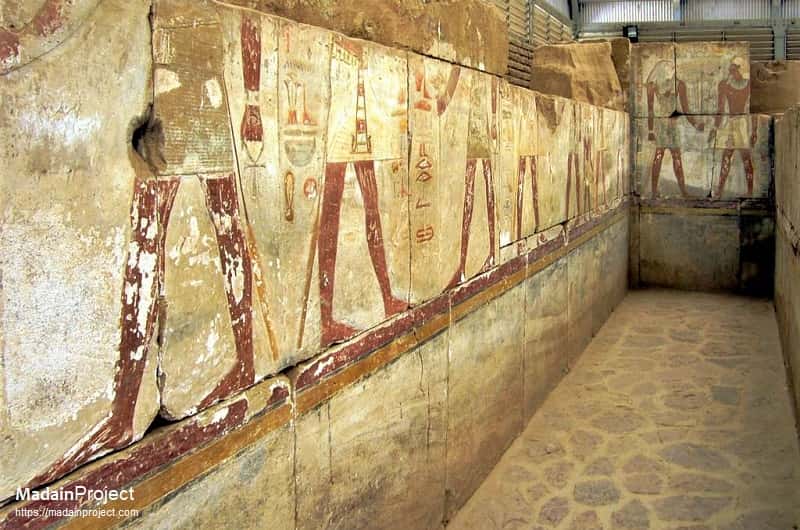
Horus Temple of Hatshepsut
The fortress of Buhen housed about 1,000 soldiers, 300 archers and their families. Queen Hatshepsut ordered a Horus temple to be built inside the Buhen fortress for worship and prayer, and also for traders to take a break while transporting their goods. Interestingly, during that time, Egypt imported and exported many products, such as oils, ivory, pottery, and tiger and elephant skins.
Commissioned by the Eighteenth Dynasty pharaoh Hatshepsut during her reign (circa 1479–1458 BCE), the Temple of Horus at Buhen represents a significant example of Egyptian imperial religious policy in ancient Nubia. Erected within the formidable Middle Kingdom fortress, the temple was dedicated to the local patron deity, Horus, Lord of Buhen, and served both as a site for official cultic activities and a point of assimilation for Egyptian administrative personnel. Its strategic placement underscores Egypt's military and political authority over the region, where the religious edifice acted as a vital tool of cultural control and legitimation of pharaonic rule.
Before the inundation caused by the Aswan Dam in 1964 CE submerged the site under Lake Nasser, the temple was dismantled during the UNESCO salvage campaign and subsequently re-erected in the garden of the Sudan National Museum in Khartoum, where its architectural and epigraphic program can still be studied. Archaeological and epigraphic analyses of the relocated structure provide critical insights into the expansionist New Kingdom project and the complex interactions between Egyptian and Nubian cultural spheres.


Signup for our monthly newsletter / online magazine.
No spam, we promise.
The Madain Project is an online archive of Abrahamic History and Archaeology.
Abrahamic History & Archaeology is the study of history and archaeology with respect to the three Abrahamic Faiths without considering the religious and theological aspects. The goal of Abrahamic History is to understand how and why the religious doctrines and behaviours have evlovled and changed over time. Searching for patterns in the evolution of significant cultural events such as the development of farming, the emergence of cities, or the collapse of major civilizations for clues of why and how these have influenced the three major Abrahamic religions.
Cloud Drive -
About -
Help -
Privacy Policy -
Contact
Madain Project: Encyclopedia of Abrahamic History & Archaeology.
Copyright MadainProject 2017 - 2026.
![]()
![]()
![]()
![]()
![]()
![]()