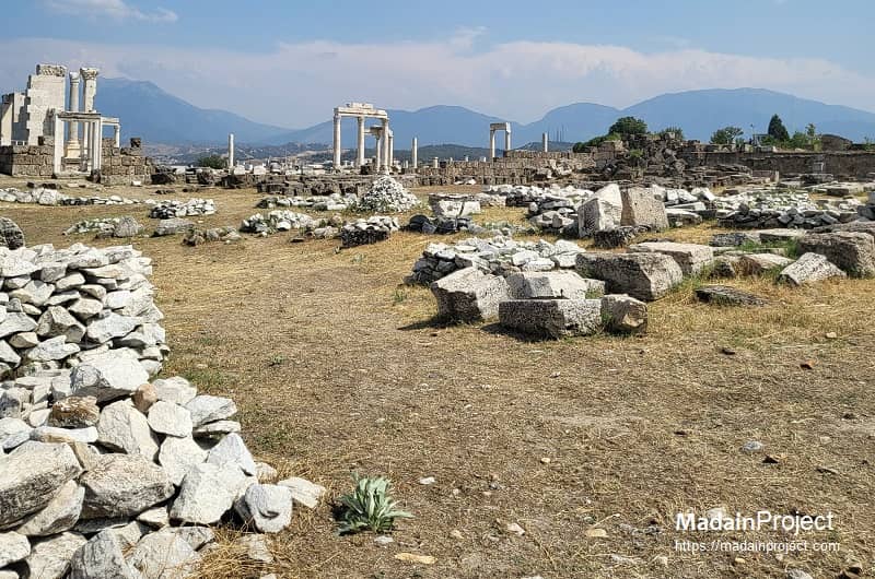
Laodicea on the Lycus (Laodikeia) was a prosperous ancient Greek city of Asia Minor, later incorporated into the Roman Empire. Founded in the Hellenistic period, it flourished as a commercial, cultural, and administrative centre, particularly under Roman rule when it became part of the province of Phrygia Pacatiana. Known for its wealth, textile production, and strategic position in regional trade, Laodicea played a prominent role in the political and economic life of western Anatolia from its foundation through the Byzantine era.
The city stood on the banks of the Lycus River (modern Çürüksu) near its junction with the Maeander, in a fertile valley surrounded by significant ancient urban centres. It lay approximately 17 kilometers west of Colossae, 10 kilometers south of Hierapolis, and 160 kilometers east of Ephesus. While situated within the broader cultural sphere of Phrygia, ancient authors differed on its precise provincial affiliation—an unsurprising variation given the shifting and often ill-defined territorial boundaries of the time. Ptolemy and Philostratus classified Laodicea as part of Caria, whereas Stephanus of Byzantium assigned it to Lydia. This intersection of Carian, Lydian, and Phrygian territories contributed to Laodicea’s diverse cultural life, blending indigenous Anatolian traditions with Hellenistic and, later, Roman influences. In modern geography, its ruins lie near the contemporary city of Denizli in southwestern Türkiye, occupying a key position on a major trade route linking the Aegean coast with the Anatolian interior.
In the early Christian era, ancient Laodikeia was one of the Seven Churches of Asia addressed in the Book of Revelation.

Pre-Hellenistic Period
The site of Laodicea on the Lycus occupies a strategic hilltop overlooking the Lycus River, near its confluence with the Maeander. Archaeological evidence indicates human settlement here during the late pre-Hellenistic era, though the precise cultural identity of the inhabitants remains partly speculative. The area was likely part of a broader network of Phrygian settlements, characterized by fortified hilltop acropolises and dispersed rural habitations. The fertile valley below supported agriculture, particularly grain cultivation and viticulture, which later contributed to the city’s enduring prosperity. Pliny the Elder records that prior to its Hellenistic foundation, the site may have been known as Diospolis, “City of Zeus”, and subsequently Rhoas, reflecting early religious associations and the continuity of settlement in the region.
Greek Period
Prior to its formal Seleucid foundation, the site of Laodicea on the Lycus lay within a cultural landscape strongly influenced by Hellenic settlements in Anatolia following the campaigns of Alexander the Great (356–323 BCE). Greek settlers and administrators introduced urban planning concepts, monumental architecture, and civic institutions characteristic of the Hellenic world, including agora-based marketplaces, temples dedicated to the Olympian pantheon, and gymnasia for education and social assembly. The city likely participated in regional networks of Greek cities, maintaining commercial and cultural exchanges with coastal centres such as Ephesus, Colophon, and Miletus.
Archaeological evidence from this period, though fragmentary, suggests that the pre-Seleucid settlement included stone-built structures and fortifications that would later be incorporated or rebuilt by Antiochus II. Religious practices may have blended local Phrygian cults with imported Greek deities, as indicated by inscriptions and cultic remains elsewhere in western Anatolia. This Hellenic phase provided both the civic template and the economic foundations upon which Laodicea’s later Seleucid and Roman prosperity was built.
Hellenistic Period
Laodicea was formally founded as a city during the reign of Antiochus II Theos, king of the Seleucid Empire, circa 261–253 BCE. The city was named in honour of his wife, Laodice, as part of a wider pattern of Seleucid urban foundations across Asia Minor. Its location on the Lycus River facilitated trade and communication between inland Phrygia and the western coast. The city rapidly became economically significant, attracting settlers including a notable population of Jews relocated from Babylonia by royal edict. Cicero later records that the city contributed annually a substantial sum of gold to the Temple in Jerusalem, indicating the organized presence and influence of this community.
During the early Hellenistic period, the city experienced regional conflicts. In 220 BCE, the local Seleucid general Achaeus declared himself king of the region, but Antiochus III, known as Antiochus the Great, reconsolidated Seleucid control in 213 BCE. These political fluctuations did not diminish Laodicea’s commercial growth, which benefited from its fertile hinterland and proximity to major trade routes connecting the Aegean coast and central Anatolia.
Roman Period
Following the defeat of the Seleucid forces at the Battle of Magnesia in 188 BCE, Laodicea came under the influence of the Kingdom of Pergamon, formalized by the Treaty of Apamea. With the death of Attalus III in 133 BCE, Pergamon’s territory, including Laodicea, was bequeathed to Rome, and the city received the status of a free city under Roman administration. Despite significant disruption during the Mithridatic Wars of the first century BCE, Laodicea quickly recovered, leveraging its strategic location and economic resources to become one of Asia Minor’s principal commercial centres. The city gained particular renown for its trade in black wool and for facilitating large-scale financial transactions. Its wealth is noted in contemporary literary sources, including the New Testament, which references Laodicea’s material prosperity.
Laodicea also served as the chief city of a Roman conventus, a judicial district comprising twenty-four cities. Cicero records presiding over assizes here around 50 BCE. Strabo emphasizes that the city’s celebrity derived not only from the fertility of its surrounding land but also from the opulence of its citizens, such as Hiero of Laodicea, who endowed the city with numerous public buildings and a bequest exceeding 2,000 talents. Wealthy inhabitants cultivated Greek arts, philosophy, and medicine, evidenced by the existence of a renowned medical school and the association with notable sceptic philosophers, including Antiochus and Theiodas, successors of Aenesidemus in the first century BCE.
Imperial Roman Era
The city minted its own coinage, depicting deities such as Zeus, Apollo, and Æsculapius, alongside imperial iconography, reflecting both religious devotion and civic identity. Laodicea was repeatedly affected by seismic activity, most notably the devastating earthquake of 60 CE during emperor Nero’s reign. Remarkably, the inhabitants opted to rebuild the city independently, declining imperial assistance, a decision that attests to the civic pride and resources of its elite. Laodicea was also the site associated with the martyrdom of Lulianos and Paphos, further marking its significance in early Christian history.
By the mid-1st century CE, Laodicea had entered the historical record of early Christianity. It is referenced in the Epistle to the Colossians (Colossians 4:15–16) and in the Book of Revelation (Revelation 3:14–22), the latter portraying the congregation as "lukewarm" in faith. The city’s growing Christian presence coincided with continued Jewish activity, reflecting a complex religious landscape. According to later traditions, the martyrdom of Lulianos and Paphos also took place here, underscoring its role in the formative centuries of the Christian movement.
Byzantine and Medieval Periods
Byzantine sources frequently mention Laodicea, particularly during the Komnenian era. In 1119 CE, Emperor John II Komnenos, accompanied by his chief general John Axouch, captured the city from the Seljuk Turks, marking a major military achievement of his reign. Manuel I Komnenos subsequently fortified Laodicea, reinforcing its strategic importance in western Anatolia. Between 1206 and 1230 CE, the city was governed by Manuel Maurozomes, a semi-independent local ruler. However, Laodicea’s fortunes declined with successive invasions by Turkish and Mongol forces, culminating in widespread destruction and depopulation. Despite these challenges, the city remained a recognizable settlement into the late medieval period, its remnants reflecting layers of Hellenistic, Roman, and Byzantine urban planning and monumental architecture.
circa 150 BCE
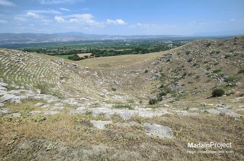
West Theater
Built on natural ground as per Hellenistic tradition the western theater sloping steeply down to the orchestra is the early theatre of the city. There are three reasons for this theatre to face west: Firstly, this side faces the early settlement of the city; secondly, the topography of the site is suitable for building a theatre; and thirdly, it as aimed to make use of the westerly winds of the afternoon.
The monument has a capacity of seating about 8,000 people; its cavea is divided into nine cunei with eight stairways (crepis). In addition there are stairways in both terminals of the analemma wall. Excavations have shown that the lower part of the cavea has 23 rows of seats and the upper cavea has 19 rows. The diameter of the cavea reaches 98.5 meters at the vaulted strolling diazoma at the top including the analemma wall. The lower cavea and architectural sculpture of the stage building's façade are of marble whereas the rest is of travertine blocks. Some marble seating blocks in the upper cavea should be from later repairs.
The west theatre functioned from the Hellenistic period through the big earthquake in the reign of Focas (reigned 602-610 CE). Thereafter, like the other structures in the city it served as a stone quarry and limekilri. The West theatre was extensively restored (circa 2021/22) with virtually complete banks of stone seats
circa 110 CE
Trajanic Nymphaeum
The Trajanic Nymphaeum of Laodicea, constructed during the reign of Emperor Trajan (circa 98–117 CE), was a monumental fountain complex designed to honor the emperor while providing a vital water source for the city. Strategically situated near the northern agora, it featured an ornate façade with multiple niches, columns, and statuary, reflecting the city’s wealth and its integration of Roman architectural grandeur. Water was supplied through the city’s aqueduct system, cascading into a series of basins before distribution. Beyond its practical function, the nymphaeum symbolized civic pride, imperial loyalty, and the fusion of public utility with elaborate urban beautification.
circa 130 CE
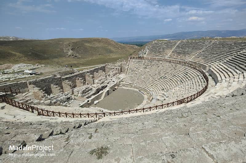
Northern Theater
When the Hellenistic period western theater could not answer the needs of the increasing urban population the north theater was built in the second century CE. Facing northeast this theatre has a panoramic view towards the Lycus Plain, former lake there, Hierapolis, and Mount Çökelez.
It was built on the hillside as per the recommendations by Vitruvius and has an almost horseshoe shape. The stage building, façade, and cavea were all built with marble and altogether cover an area of 1600 square meters. The cavea has 23 rows of seats in the lower cavea and 26 rows in the upper cavea; the lower cavea is divided into nine cunei with eight stairways whereas the upper cavea is divided into 16 cunei with 15 stairways. The building's capacity is about 12,000 people. The cunei reach a width of 11.5 to 12.5 meters depending on the curvature and the cavea's diameter is 112 meters and reaches 121.5 meters including the analemma. Thus, the cavea and the orchestra are bigger than a semicircle.
Based on the size of the monument the stage building is thought to be three-storeyed. Extant piers indicate that the vaulted passageway was reinforced with arched projections thus improving its resistance. To the south of the analemma are rows of shops serving the spectators. In the east part of the theater are blocks for fixing the tents (velarium / velum) that protected the spectators from the sun and also improved acoustics by preventing echoing.
In addition there are holes in the rows of seats where portable parasols were erected to protect the spectators from the sun. Diazoma flooring of marble bears marks of northward land-shifts caused by earthquakes in time. The calcareous layer covering all the orchestra podium blocks and traces of pink plaster to make the area waterproof all point to the fact that this theatre was used for water games (colymbethra). Rows of seats bear Greek inscriptions designating numbering, reservations for guilds, associations, or dynasties. This is of importance because it shows that there are seats reserved for other cities of the Lykos Valley and some association members.
This theater remained in use from the second until the seventh century CE. From then until 1990 CE it was exploited as a quarry and limekiln.
circa 160 CE
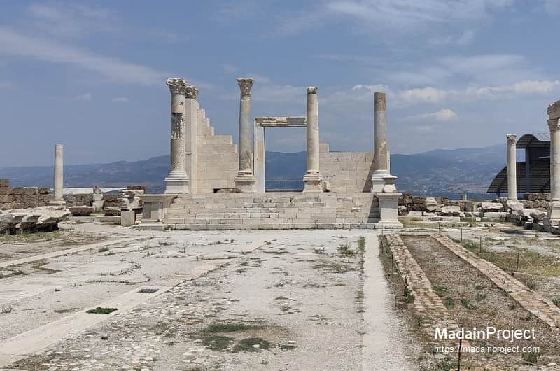
Temple A
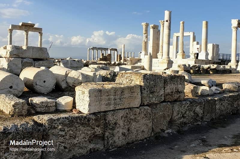
Located to the north of the so-called Syria Street, Temple A covers two insulae (58x42.33 meters) and is surrounded with porticoes. The prostyle temple of Corinthian order is positioned at the north end of the courtyard. The naos rises on a high platform built with travertine blocks and faced with marble. A stairway of seven steps bounded with marble banisters on both sides leads up to the naos. Both ends of both banisters are arranged as statue pedestals with Greek inscriptions. The pronaos is paved with marble.
The temple proper comprises the naos and a vaulted chamber beneath it. The vaulted subchamber is accessed via a doorway of 1.00 meters in width and a flaring oval stairway of seven steps built with bricks at the southeast corner. This subchamber actually served for storing the gifts to the temple and was converted to an archive of the Church of Laodikeia nearby following the liberation of Christianity in the reign of Constantine the Great (reigned 307-337 CE). The courtyard is accessed from the south via a double- winged doorway 2.60 meters in width. The threshold was built with three marble slabs and the outer walls of the courtyard were built with double rows of travertine blocks. The court is paved with marble slabs and the porticoes are two steps higher. The number of columns and pilasters surrounding the courtyard adds up to 54. The sewage system running parallel to the crepis in the east-west direction forms a U-shape, thus draining rainwater efficiently. The courtyard has two north-south pools, one in the east and the other in the west. During the late antiquity a chapel and a lavatory was built bordering the portico's step.
Temple A was originally dedicated to deities Apollo, Artemis and Aphrodite as well as the Roman imperial cult. It was built in the second half of the second century CE (Antonine period), and heavily repaired in the reign of emperor Diocletian (reigned 284-305 CE). According to the inscription on the front ends of the stairway banisters the demos (public assembly) and boule (advisory council) honoured most likely Diocletian and Maximian. The building transformed to an archive of the church with the spread of Christianity in the fourth century CE and collapsed with the earthquake of 494 CE. As the area served as a quarry after the catastrophe of 494 CE, there were very few bricks and architectural blocks uncovered in the naos; however, the courtyard and surrounding area remained in use until the big earthquake of early seventh century.
During the restoration work, a total of 19 columns were re-erected - four in the prostyle of the temple and 15 of the porticoes. Stairs and banisters of the temple proper were restored. The naos's doorway has been erected as per anastylosis and the side walls were raised giving the depth of third dimension. The vaulted subchamber was roofed over with steel and glass construction creating a panoramic terrace to watch the Lykos plain and Pamukkale in the distance as well as allowing a view of the interior.
circa 200 CE
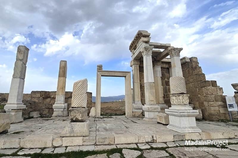
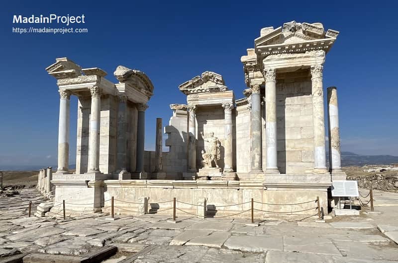
Propylon
The monumental propylon is one of the three portals of the northern or sacred Agora which was located on the Syria street opposite the western corner of the Central Agora. It forms a recess towards north from the street. The arched section and doorway leads to a four step stairway providing access to north. On two sides the sections supported with the piers and columns are covered with ceiling coffers decorated in relief while the arched passageway is covered with arch coffers with relief decorations. Believed to have been built in the Severan period, the propylon I was damaged greatly in an earthquake during the reign of Diocletian (reigned 284-305 CE) and subsequently rebuilt. It was completely destroyed again in the earthquake of 494 CE and rearranged thereafter staying in use until the seventh century CE.
circa 340 CE
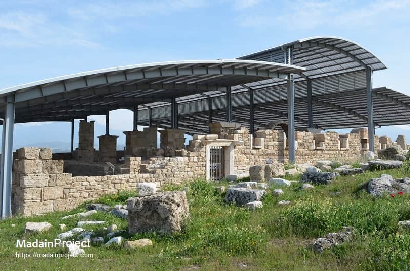
Byzantine Period Church
The Byzantine period church of Laodicea, built circa 340 CE during the reign of Constantine the Great after Christianity’s legalization, occupies a full city block northeast of Temple A and was a major pilgrimage site due to Laodikeia’s mention in the New Testament. Identified and excavated in 2010, it features an innovative plan with eleven apse-like niches, a three-aisled basilica, richly decorated opus sectile floors, mosaics bearing clerics’ names, frescoed walls, and one of the earliest well-preserved cruciform baptismal fonts. The church suffered severe earthquake damage in 494 and collapsed completely during the reign of Emperor Phocas (602–610). Notable elements include a monumental ambo (linked to the Council of Laodicea), parapeted naves possibly segregating congregants, marble and fresco wall facings, and elaborately designed pastophoria. The structure has been conserved under a protective roof with a steel-and-glass walkway for visitors.
circa 380 CE
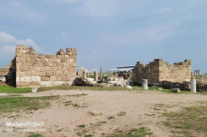
Early Byzantine Gate and Towers
The Early Byzantine Gate and Towers of Laodicea, constructed during the 4th–5th centuries CE, formed part of a substantial fortification program intended to protect the city during a period of heightened regional instability. This complex comprised a monumental arched gateway flanked by two massive, square-plan towers built primarily from large ashlar blocks, with brick and mortar reinforcement in certain structural sections. The gate functioned both as a defensive strongpoint and as a controlled entryway into the urban core, integrating with the late antique city wall circuit. Its architectural style reflects a transitional phase between Late Roman military engineering and early Byzantine urban defense design, incorporating both utilitarian robustness and ceremonial grandeur. The towers likely provided elevated vantage points for surveillance and archery, while the passageway’s scale and decoration underscored Laodicea’s continued urban importance despite the political fragmentation of the era.
Signup for our monthly newsletter / online magazine.
No spam, we promise.
The Madain Project is an online archive of Abrahamic History and Archaeology.
Abrahamic History & Archaeology is the study of history and archaeology with respect to the three Abrahamic Faiths without considering the religious and theological aspects. The goal of Abrahamic History is to understand how and why the religious doctrines and behaviours have evlovled and changed over time. Searching for patterns in the evolution of significant cultural events such as the development of farming, the emergence of cities, or the collapse of major civilizations for clues of why and how these have influenced the three major Abrahamic religions.
Cloud Drive -
About -
Help -
Editorial Policy -
AI Policy -
Privacy Policy -
Contact
Madain Project: Encyclopedia of Abrahamic History & Archaeology.
Copyright MadainProject 2017 - 2026.
![]()
![]()
![]()
![]()
![]()
![]()