A processional street, processional walkway, or the "street of the procession", is a route designated or used for ritual or ceremonial movement, often associated with religious rituals, festivals, worships, triumphs, or state occasions. Such routes could originate as ordinary civic thoroughfares that gained sacred or ceremonial significance through repeated ritual use, as in the case of the Roman Via Sacra or the Greek Sacred Way to Eleusis.
The term Processional Street usually refers to the Neo-Babylonian archetypal ceremonial avenue of Babylon. More broadly, it is used typologically to describe ritualized routes in diverse ancient or historic cultures, including those of Egypt, Mesopotamia, Arabia, and Rome. By contrast, the term Sacred Way is historically specific, primarily denoting Greek religious processional routes—such as the Hierá Hodós to Eleusis, the Miletus-Didyma Sacred Way, and certain Artemision routes. The Sacred Way carries particular cultural and ritual significance, distinguishing it from the broader architectural and urban concept of a processional street, which encompasses ceremonial avenues across multiple civilizations [see Note 2].
The concept of the processional street appears across a wide chronological and geographical spectrum. In Mesopotamia, paved avenues such as Babylon’s Aj-ibur-šapu were lined with glazed reliefs symbolizing divine power. In Egypt, sphinx-lined causeways connected temple precincts and facilitated festival rituals. The Hellenistic and Roman worlds incorporated colonnaded boulevards that doubled as civic axes and ceremonial routes, such as the Great Colonnade at Apamea or the Via Sacra in ancient Rome. In some cases a processional path may also be an indoor passage, built as part of a larger palatial or imperial building. Although the architectural forms varied, the underlying function—ritualized movement through a monumentalized urban space—was consistent.
In Babylon, the Akītu festival required the movement of Marduk’s cult statue along the Processional Street to the bit akītu. In Egypt, statues of Amun traveled between Karnak and Luxor during the Opet festival. In Rome, victorious generals paraded their armies and spoils on the Via Sacra during triumphs. In each case, the street’s physical fabric and symbolic decoration reinforced the authority of king, state, or deity.

circa

Processional streets were often paved in durable materials, such as stone or baked brick set in bitumen, and wide enough to accommodate ritual cortèges, cult statues transported on carts, or priests carrying sacred icons. In many cases, however, the routes originated as ordinary thoroughfares or functional pathways, which gained ceremonial significance through repeated ritual or civic use. Monumental decoration, when added, emphasized the street’s sacred or political role: Babylonian walls carried glazed-brick reliefs of lions, dragons, and bulls; Egyptian avenues were flanked with rows of sphinxes or rams; and Hellenistic cities created continuous colonnades, monumentalizing the urban axis itself. Even in cases where the street remained architecturally modest, its designation as a processional route—whether for a festival, triumph, or pilgrimage—transformed its social and ritual meaning. The routes often terminated at significant cultic or civic foci, such as the bit akītu in Babylon, the Karnak Temple in Thebes, or the Temple of Jupiter Optimus Maximus in Rome, highlighting the interplay between ordinary urban circulation and ceremonial performance.
circa 1700–1450 BCE
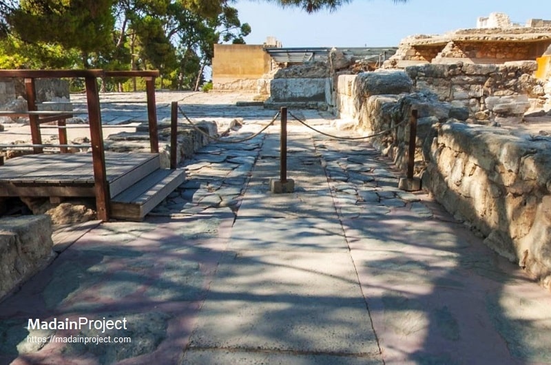
Corridor of Processions (Knossos)
The Processions Corridor of the Minoan Palace at Knossos functioned as a meticulously designed threshold, mediating the transition from the palace's public exterior to its sacred inner sanctums. Its deliberate architectural and iconographic program structured the movement of participants, transforming a physical journey into a ritual performance. Adorned with the now-famous frescoes, depicting gift-bearers in a stately procession, the walls served as a performative narrative, imbuing the journey with religious significance and reinforcing the palace's social and divine hierarchies. The corridor's deliberate width, finely finished floor of gypsum and plaster, and connection to the West Court and Central Court reveal its role as a monumental axis. This design demonstrates the Minoan elite's sophisticated understanding of how architecture could manipulate spatial perception and ritual experience to reinforce political authority and sacralize palace life.
circa 1400–300 BCE

Avenue of the Sphinxes (Karnak–Luxor, Egypt)
The Avenue of the Sphinxes, also called the Rams Road, extended approximately 2 kilometers between Karnak and Luxor Temples in Thebes. Constructed primarily during the New Kingdom and completed under the 30th Dynasty ruler Nectanebo I, the avenue was lined on both sides with hundreds of sphinx and ram-headed statues, creating a continuous sculptural corridor. The avenue functioned as the ceremonial route for the Opet festival, during which statues of Amun-Re, Mut, and Khonsu were transported between the two temples. Its alignment reinforced axial symmetry and sacred orientation, connecting the city’s principal cultic precincts. Modern excavations and restoration projects, completed in 2021 CE, revealed its original scale and ceremonial prominence, highlighting the avenue’s dual function as urban axis and sacred passage.
circa 700-600 BCE
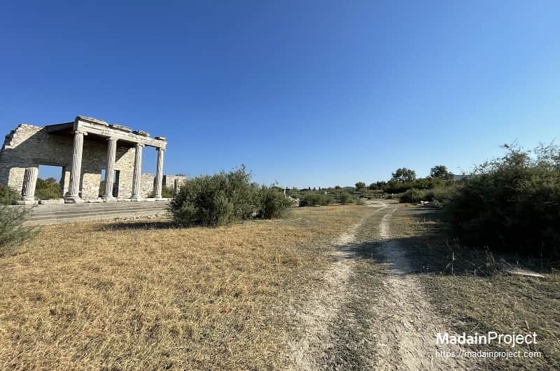
Miletus-Didyma Sacred Way
The Sacred Way connecting Miletus to the Sanctuary of Apollo at Didyma was one of the most famous processional walkways of the ancient world. Stretching for approximately 17 to 20 kilometers, this paved road facilitated an annual pilgrimage for the festival of Apollo. The procession, which began at the Sacred Gate of Miletus, was a testament to the strong religious and civic ties between the city and its oracle at Didyma, renowned as a rival to ancient Delphi. The path's significance evolved over centuries, with its earliest traditions believed to date back to the Archaic period (6th–7th centuries BCE), when it was first lined with monumental statues, some of which depicted Milesian aristocrats.
The physical route of the Sacred Way itself was a work of art, featuring multiple ritual stops and impressive sculptural decoration. The most well-documented section was the final 3.5 kilometers from the coastal port of Panormos to the temple sanctuary. This stretch was adorned with sphinxes, lions, and colossal seated statues of figures like the Branchidae priests, with many of these Archaic sculptures now housed in major museums like the British Museum and the Pergamon Museum in Berlin. In the Roman Imperial period, the road was extensively renovated, notably under Emperor Trajan around 101–102 CE, which included the repaving of the route and the rebuilding of the Sacred Gate. These physical and ceremonial features transformed the journey from a simple path into a sensory-rich ritual, making the Sacred Way a potent symbol of Milesian identity and a vital conduit for the flow of pilgrims, ideas, and offerings throughout antiquity.
circa 700–500 BCE

Artemision Processional Route (Ephesus, Turkey)
The Artemision processional route of Ephesus was the ceremonial way along which the cult image of Artemis was carried during the great festivals of the city. The goddess’s temple, the Artemision, lay outside the urban perimeter, necessitating a ritualized path that linked the sanctuary with the civic core. The route is first implied in the Archaic period, when the earliest phases of the Artemision (7th–6th century BCE) stood on the Cayster plain, though it became more clearly defined in the Classical and Hellenistic periods as the cult’s festivals gained pan-Ionian prominence.
The principal ritual artery of ancient Ephesus was the processional route that connected the great Temple of Artemis (Artemision) with the urban center. Unlike the Curetes Street, which was primarily a civic and honorific avenue, this route was defined by the annual Artemisia (or Ephesia) festivals held in honor of Artemis, the city’s tutelary deity. The festivals lasted several days and were framed by athletic contests, musical competitions, and civic gatherings, but their centerpiece was the grand procession (pompe) in which a festively adorned cult statue of Artemis was carried in state. This ritual movement symbolized the goddess’s visitation to her city, since her sanctuary lay outside the inhabited core.
Archaeological and textual sources allow the outline of the route to be reconstructed. The procession began at the Artemision, one of the largest sanctuaries of the ancient Mediterranean, before entering the city through the Magnesian Gate. From there it proceeded past the State Agora, then ascended the Curetes Street, lined with honorific monuments, to the Great Theatre. After ceremonial rites in the theatre, the procession turned along the Theatre Street, exiting the city through the Colonnaded Street between the Stadium and the Vedius Gymnasium, before looping back to the Artemision. The effect was to link the extra-urban sanctuary with the civic, cultural, and performative heart of the polis, embedding Artemis into both religious and political life.
Chronologically, the route is believed to have been in use from at least the Archaic period, when the earliest Artemision temples (7th–6th century BCE) would have required processional access. By the Classical and early Hellenistic eras, the festival was already central to Ephesian identity, with processions documented in literary references. The monumentalization of the streets and gates in the Hellenistic city plan (3rd–2nd century BCE) formalized the processional axis, creating a staged civic theatre for the goddess’s movement. In the Roman period, particularly after the foundation of C. Vibius Salutaris in 104 CE, the ritual was further regulated: inscriptions explicitly prescribed the carrying of Artemis’s images and cult apparatus along this route, giving us the clearest testimony to its operation.
The Artemision processional route thus illustrates a distinct type of ceremonial street, not merely a single paved avenue but a ritual circuit through urban and peri-urban space, binding the sanctuary to the city. Unlike Babylon’s Processional Street, which was a straight monumental thoroughfare, the Ephesian example operated as a looping festival axis, blending sacred movement with civic display. Its layered evolution—from an Archaic ritual path, to a Hellenistic monumentalized axis, to a Roman legally codified procession—makes it one of the most illustrative case studies in the archaeology of processional space.
circa 700–500 BCE

Sacred Way to Eleusis
The Sacred Way (Hiera Hodos) was the principal ceremonial route connecting Athens to the sanctuary of Demeter and Kore at Eleusis, spanning roughly 21 kilometers through the Athenian plain and the Thriasian territory. Its ritual function is attested from the 7th century BCE, when the Eleusinian Mysteries were already established, with the full procession route formalized by the 5th century BCE during the Classical period / Classical Greece. Pilgrims, known as mystai, traveled on foot from the Dipylon Gate of Athens along a marked path that passed through the Athenian countryside, rural shrines, and sacred groves, culminating at the Telesterion, the main hall at Eleusis. Along the way, ritual stations and monuments—such as the hierophant’s altars, boundary markers (horoi), and votive offerings—structured the procession and reinforced the sacred geography of the route. While largely unpaved in its early phases, sections near Athens and Eleusis were later leveled and surfaced to facilitate large groups during the festival. The Sacred Way thus represents a hybrid processional route: part natural landscape corridor, part architecturally and ritually structured path, used consistently over centuries for the culmination of the Eleusinian Mysteries.
circa 650 BCE

Via Sacra (Rome, Italy)
The Via Sacra, or Sacred Way, was the main processional street through the Roman Forum, linking the Capitoline Hill to the Colosseum area. Originally a practical thoroughfare, it acquired ritual significance as the designated route for triumphal processions, during which victorious generals displayed spoils of war, captives, and their armies before culminating at the Temple of Jupiter Optimus Maximus. Sometime during the Republican period the street was paved with stone slabs and lined with temples, arches, and public monuments, integrating the ceremonial and civic dimensions of the city. Its repeated use in religious festivals, political ceremonies, and triumphs transformed an ordinary urban street into a ritualized axis of Roman state power.
circa 604–562 BCE

Processional Street of Babylon
The Processional Street of Babylon, known in Akkadian as Aj-ibur-šapu, was the principal ceremonial avenue of the Neo-Babylonian capital under Nebuchadnezzar II (reigned 604–562 BCE). Extending northward from the Ishtar Gate to the bit akītu (New Year house) beyond the city walls, the street was paved with large stone slabs set in bitumen and reached widths of approximately 20 meters.
Its flanking walls were decorated with glazed-brick reliefs of striding lions, mušḫuššu dragons, and bulls, representing the protective power of Marduk, Ishtar, and Adad. The street was central to the Akītu festival, during which cult statues were carried along the avenue in elaborate processions that reaffirmed divine kingship. Excavations by Robert Koldewey (1899–1917 CE) revealed both the pavement and the decorative walls, and fragments of these reliefs were later reconstructed in the Pergamon Museum.
circa 550 BCE
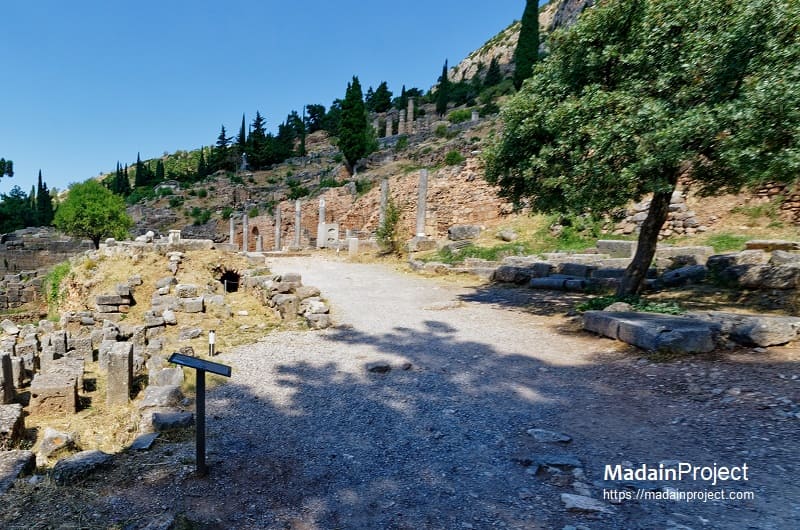
Sacred Way (Delphi, Greece)
The Sacred Way of Delphi in central Greece represents one of the most celebrated processional routes of the ancient world, leading from the lower entrance of the Sanctuary of Apollo up to the Temple of Apollo itself, situated on the southern slopes of Mount Parnassus. The winding, marble-paved path—approximately 200 meters in length—was the central artery of religious and ceremonial life in Delphi, used during major festivals such as the Pythian Games and other oracular processions. Along its ascent, the Sacred Way was flanked by an extraordinary sequence of treasuries, votive monuments, stoas, and inscribed bases erected by Greek city-states and individuals in thanksgiving for victories, dedications, and divine favor. These included the Athenian Treasury, the Siphnian Treasury, and numerous statues and tripods, transforming the route into an open-air museum of Panhellenic devotion and political prestige. Architecturally, the Sacred Way was carefully designed to enhance the ritual journey, with the path curving to gradually reveal the temple and the Pythia’s seat, thereby heightening the sense of reverence and anticipation. The route’s layering of religious symbolism, artistic display, and civic representation encapsulated the Greek ideal of piety intertwined with civic identity, making the Sacred Way not merely a physical road but a spatial manifestation of Delphi’s role as the spiritual and cultural navel of the Greek world.
circa 400-200 BCE
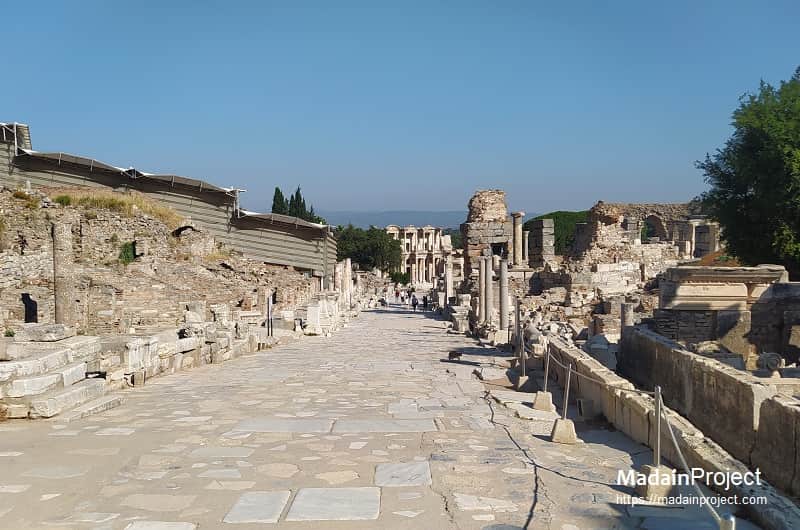
Avenue of the Curetes (Ephesus, Turkey)
The Avenue of the Curetes was a marble-paved ceremonial path running through the sanctuary area of ancient Ephesus, connecting key temples and civic spaces. Curetes Street in ancient Ephesus was used for processions, serving as a major sacred and processional way that led to the Temple of Artemis. It served as the city's main thoroughfare, named after the priests who, according to a legend, aided in the birth of Artemis and Apollo, and ran from the Hercules Gate to the Celsus Library.
Lined with statues, monuments, and sculpted reliefs, it provided a formalized route for religious and civic processions, particularly those honoring Artemis and other local deities. The avenue also contained monumental arches and niches that framed the movement of participants, creating a structured spatial experience that reinforced the sacred and political significance of the city’s rituals. Its careful paving and alignment suggest that the route was not merely functional but designed to visually and symbolically organize the movement of citizens during ceremonial occasions.
circa 100 BCE- 250 CE

Via Tecta (Pergamon)
The Via Tecta at Pergamon, a monumental processional way leading to the renowned Asclepeion, represents a sophisticated fusion of civic architecture and sacred topography. While the route itself originated in the Hellenistic period, the road's defining Roman-era form—a vaulted, covered walkway—was established during the sanctuary's grand expansion in the first and second centuries CE, coinciding with its peak influence and prestige. The architectural conversion into a via tecta (covered street) was a deliberate, therapeutic intervention that served to ritually isolate pilgrims from the mundane world and focus their minds on the spiritual journey ahead.
This sheltered passage, with its controlled and often dimly lit environment, functioned as a liminal space, preparing patients psychologically for their experience in the healing sanctuary. As they proceeded along the approximately 820-meter stretch from the Lower City gate, passing first by Doric and later by opulent Corinthian-style colonnades, the sensory shift would have been profound, culminating in their arrival at the imposing Propylon. The strategic placement of this covered corridor, leading from the profane urban sphere to the sacred precincts, demonstrates a keen understanding of both monumental city planning and psychological manipulation in the service of cultic healing.
circa 10 CE

Via Dolorosa (Jerusalem)
The Via Dolorosa, meaning “Way of Suffering”, in Christian tradition, is the route traditionally believed to have been followed by Jesus on the way to his crucifixion. The traditions originate from early 1st century CE Jerusalem, but the current formalized route with marked stations developed during the medieval period under Christian pilgrimage / Franks traditions. It functions as a ritualized procession for pilgrims, especially during Holy Week, with repeated traversal reinforcing religious memory and devotion. While the street itself is urban and incorporates ordinary pathways through the Old City, its ceremonial function, commemorative stations, and ritualized movement classify it within the broader typology of processional routes.
circa 150 CE

Great Colonnade of Apamea (Syria)
The Great Colonnade at Apamea, a Hellenistic-Roman city in northwestern Syria, formed the main north–south axis of the urban plan. Rebuilt in the 2nd century CE following seismic destruction, the colonnaded boulevard extended nearly 2 kilometers and was lined with limestone columns, some reaching 9 meters in height. Beyond its function as the city’s central thoroughfare, the colonnade served as a ceremonial axis for religious and civic events, guiding processions past public monuments, basilicas, and marketplaces. The avenue’s monumental scale and regularized column spacing emphasized imperial authority and urban order, reflecting the synthesis of Greek urban design and Roman civic planning.
circa 600 CE

al-Masā’ (Mecca, Saudi Arabia)
The al-Masā’ route between the two mounds of Safa and Marwa in Mecca represents a ritualized ceremonial corridor with a unique historical evolution. Originally an open-air thoroughfare and marketplace, it later became incorporated into the expanding precincts of the Great Mosque, formalized as a multi-story covered walkway to accommodate the Sa’i ritual during Hajj and ‘Umrah. Pilgrims traverse this path in a highly structured movement commemorating Hagar’s search for water, and its repeated use for ritual purpose effectively sacralized it. Unlike monumental avenues such as Babylon’s Processional Street or Egypt’s Avenue of the Sphinxes, al-Masā’ was not originally designed as a ceremonial street; its significance derives primarily from ritual designation rather than architectural monumentalization.
The path of al-Masā’ is also historically and ritually linked to the Hajirah-Isma‘il narrative, marking the journey of Hagar (Hajirah) and her son Ishmael (Isma‘il) as they sought water in the desert. The corridor preserves the symbolic and spatial memory of this foundational event, and the repeated traversal by pilgrims reinforces its role as a living ritual axis.
Signup for our monthly newsletter / online magazine.
No spam, we promise.
The Madain Project is an online archive of Abrahamic History and Archaeology.
Abrahamic History & Archaeology is the study of history and archaeology with respect to the three Abrahamic Faiths without considering the religious and theological aspects. The goal of Abrahamic History is to understand how and why the religious doctrines and behaviours have evlovled and changed over time. Searching for patterns in the evolution of significant cultural events such as the development of farming, the emergence of cities, or the collapse of major civilizations for clues of why and how these have influenced the three major Abrahamic religions.
Cloud Drive -
About -
Help -
Privacy Policy -
Contact
Madain Project: Encyclopedia of Abrahamic History & Archaeology.
Copyright MadainProject 2017 - 2026.
![]()
![]()
![]()
![]()
![]()
![]()