The Emporium was the principal commercial river port of ancient Rome, established in the early 2nd century BCE on the left bank of the river Tiber, immediately south of the Aventine Hill. It functioned as Rome’s central hub for the unloading, storage, and redistribution of bulk goods—particularly grain, wine, olive oil, and building materials—arriving from Ostia and other Mediterranean ports. Emporium was Rome's second urban commercial port, after the first Tiber Port (Portus Tiberinus).
Closely associated with the Porticus Aemilia and later surrounded by extensive warehouse complexes (horrea), the Emporium played a crucial role in sustaining the provisioning system of Rome, including the state-organized grain distributions (annona). Its operations generated the vast pottery dump of Mons Testaceum (Monte Testaccio), one of the most visible archaeological monuments of ancient Roman trade.
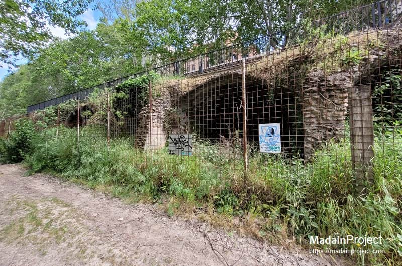
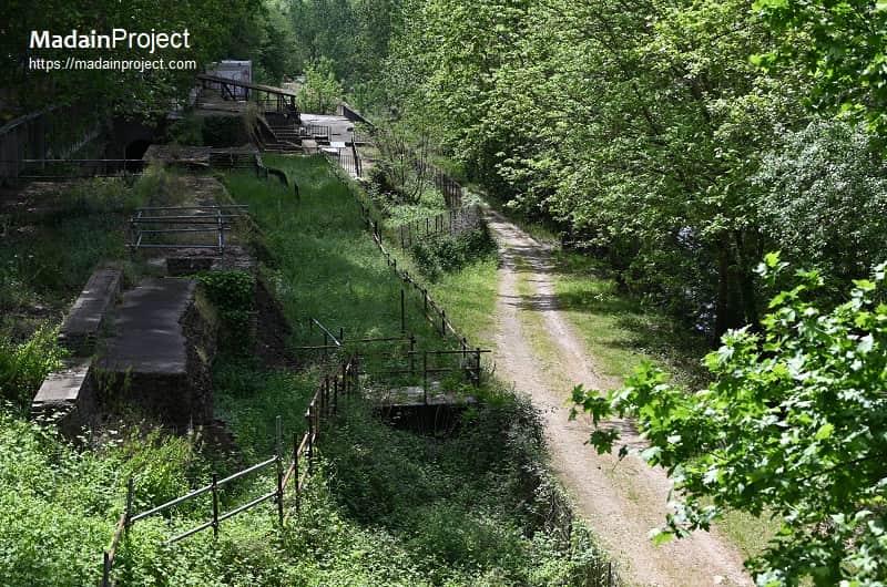
The Emporium was first systematically excavated between 1868 and 1870 CE, in conjunction with flood-control works on the river Tiber, and again in 1952 CE. Visible remains survive today as part of the embankment walls along the Lungotevere Testaccio. Archaeologists identified a quay measuring approximately 500 metres in length and 90 metres in depth, built of travertine blocks fitted with mooring holes. The layout, with steps and ramps descending to the river, closely resembles that of the port at Aquileia, though it is less well preserved.
Excavations during the development of the modern Testaccio quarter also revealed multiple warehouse foundations and individual burials, including the tomb of the consul Servius Sulpicius Galba, one of the earliest known elite sepulchres associated with the district.
circa 42 CE- Modern Period

Republican Period
By the early 2nd century BCE, Rome’s economic growth and population increase had rendered the older river port at the Forum Boarium insufficient. Its location, constrained by the surrounding hills, prevented expansion. In response, in 193 BCE the censors Lucius Aemilius Lepidus and Lucius Aemilius Paulus authorized the construction of a new commercial port south of the Aventino, at the edge of the urban settlement. At the same time, the Porticus Aemilia was erected, providing one of the earliest large-scale warehouse complexes in Rome.
In 174 BCE, the new Emporium was paved with stone and divided into sections by walls and stairways leading down to the river bank of Tiber. This infrastructure allowed efficient unloading of goods—particularly marble, grain, wine, and olive oil—that were shipped from Ostia upriver on barges pulled by draft animals along a towpath. The extensive use of amphorae for transporting liquids produced an enormous quantity of broken pottery. These fragments were systematically deposited in the vicinity, forming the artificial mound known as Mons Testaceum (modern Monte Testaccio). Archaeological estimates suggest that the mound accumulated roughly 25 million discarded amphorae over several centuries.
Late Republican and Early Imperial Period
By the late Republic, the Emporium had become a central hub in Rome’s provisioning system. Grain distributions (annona)—which grew in importance from the reforms of Tiberius Gracchus in 123 BCE onward—intensified the need for large storage facilities near the port. Warehouses (horrea) proliferated in the surrounding district, including the Horrea Sempronia, Galbana, Lolliana, Seiana, and Aniciana. These complexes stored grain, olive oil, wine, and other goods essential to the city’s food supply.
Imperial Period
During the reign of Trajan (98–117 CE), the Emporium underwent substantial redevelopment. New structures in opus mixtum masonry were added, and the Testaccio plain was progressively filled with horrea, consolidating the district as the main commercial and storage zone of Rome. The expansion coincided with the systematization of free food distributions to Roman citizens, which significantly increased the throughput of goods passing through the port.
circa 90 CE
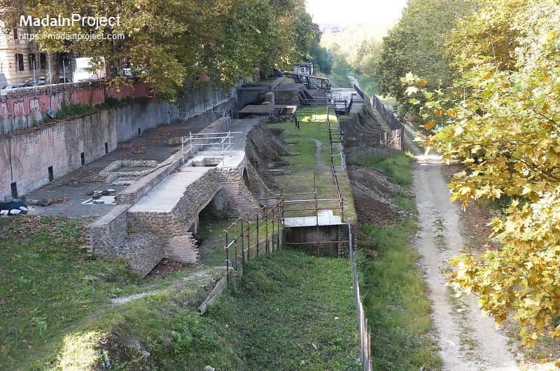
The architecture and plan of the Emporium (the emporium or river-port quarter on the left bank of the river Tiber, south of the Aventine) reflect a deliberate organisation of river access, covered storage and hinterland horrea that developed from the early Republican foundation into a large Imperial complex. The monumental rectilinear structure conventionally identified as the Porticus Aemilia — the best-preserved architectural marker of the Emporium — is reconstructed from standing walls, the Severan Marble Plan and modern excavations as a concrete, opus incertum building roughly 487 × 60 metres, subdivided by regular rows of piers into some fifty parallel aisles (each c. 8.3 m wide) and roofed by a series of barrel vaults; this long, multi-aisled hall lay parallel to the river and was set back approx. 90 meter from the quay, creating an intervening functional zone for smaller structures and circulation.
Direct river access was provided by a long travertine-paved quay fronted by steps and ramps that descended to the water; regular travertine mooring blocks (some pierced or sculpted) and slots for ropes attest to deliberate ship-landing points and to the need to secure barges against the river’s currents. Behind that quay a line of warehouses and lower cryptoportici ran parallel to the Tiber, while the larger covered aisles of the Porticus (or related multi-room horrea) occupied the raised plain behind them.
Internally the storage architecture combined broad, columned/arcaded aisles with subsidiary enclosed rooms and raised floor systems (suspensurae) in places, a practical solution for ventilated grain storage and protection from damp: archaeological excavation has revealed suspensurae, offsets and layered floors consistent with horrea practice elsewhere in Rome and Ostia Antica. In the open area between quay and portico the pattern of smaller rectangular store-rooms, triangular-plan warehouses and courtyard-centred horrea (the Horrea Galbana and related complexes are documented immediately southeast of the Porticus) shows a mixed programme of bulk storage, sorting and administrative offices rather than a single monofunctional shed.
Phasing is visible in the masonry and plan: Republican foundations and later restorations were augmented in the early Imperial centuries with opus mixtum repairs and internal subdivision to cope with higher throughput (especially after institutionalised grain distributions); recent scholarship also highlights a persistent interpretative issue — whether portions of the surviving mass should be read as horrea, navalia (shipsheds) or mixed-use storage — a debate grounded in differing readings of the Forma Urbis fragments and the standing fabric.
Finally, the plan of the Emporium must be read in landscape terms: the concentration of specialised oil amphorae and other discarded containers immediately to the south produced the artificial mound of Monte Testaccio, which functions as a material index of the Emporium’s throughput and the spatial logic that placed docks, short-distance unloading zones, covered storage and administrative rooms in a compact, river-oriented plan. Estimates for the amphorae accumulated there vary in the literature, but the mound’s scale materially confirms the Emporium’s role as Rome’s primary inland transshipment and storage complex.
Signup for our monthly newsletter / online magazine.
No spam, we promise.
The Madain Project is an online archive of Abrahamic History and Archaeology.
Abrahamic History & Archaeology is the study of history and archaeology with respect to the three Abrahamic Faiths without considering the religious and theological aspects. The goal of Abrahamic History is to understand how and why the religious doctrines and behaviours have evlovled and changed over time. Searching for patterns in the evolution of significant cultural events such as the development of farming, the emergence of cities, or the collapse of major civilizations for clues of why and how these have influenced the three major Abrahamic religions.
Cloud Drive -
About -
Help -
Editorial Policy -
AI Policy -
Privacy Policy -
Contact
Madain Project: Encyclopedia of Abrahamic History & Archaeology.
Copyright MadainProject 2017 - 2026.
![]()
![]()
![]()
![]()
![]()
![]()