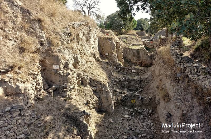
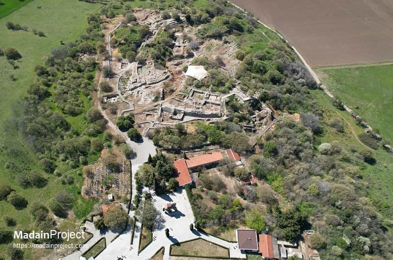
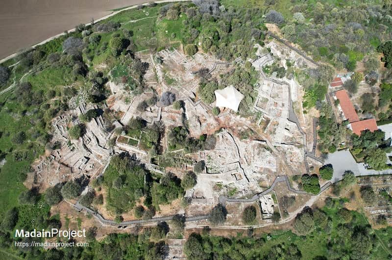
The stratigraphic phases of ancient Troy refer to the sequential archaeological layers identified at the mound of Hisarlık in northwestern Anatolia, where the site of ancient Troy is located. These layers represent successive phases of occupation, construction, destruction, and rebuilding at the site, extending from the early Bronze Age through the Roman period. The phases are conventionally labeled Troy 0 through Troy IX, with some further subdivided (e.g., Troy VIh or VIIa) based on distinct architectural, ceramic, and cultural traits.
Troy's stratigraphy, first exposed during the 19th-century excavations by Heinrich Schliemann and subsequently clarified by Wilhelm Dörpfeld, Carl Blegen, and later Manfred Korfmann and Ernst Pernicka, forms one of the most complex stratigraphic records in the eastern Mediterranean. The mound preserves more than 4,000 years of human occupation, from circa 3000 BCE to circa 500 CE. Each stratum reflects major shifts in urban planning, regional interaction, economic organization, and responses to warfare or natural disasters. While early scholars associated specific layers with Homeric Troy, modern consensus refrains from such direct identifications, instead emphasizing archaeological integrity and cross-cultural synchronisms.
circa 3000–2550 BCE
Troy I
Troy I, established circa 3000 BCE on the eastern shore of what was then a shallow lagoon, occupied a citadel of less than one hectare, making it significantly smaller than later settlements at Hisarlık. The settlement was distinguished by massive limestone fortification walls, repeatedly renovated and strengthened, marking the beginning of a defensive architectural tradition that persisted through later phases. Domestic structures consisted of attached stone-and-mudbrick houses, some with megaron-type layouts, oriented roughly parallel to the southern fortifications.
Material culture from this phase includes dark, burnished handmade pottery, copper objects, and a large carved stone stele depicting an armed warrior. The founding population appears to have been drawn from earlier nearby sites such as Kumtepe and Gülpınar, which had been part of a regional network with strong cultural and economic links to the eastern Aegean and southeastern Europe, sharing traits with sites such as Poliochni (Lemnos), Thermi (Lesbos), and settlements in Thessaly. While some affinities with Anatolian sites like Bademağacı are evident, close connections with central Anatolia had not yet developed. The settlement was destroyed by fire circa 2550 BCE.
circa 2500–2300 BCE
Troy II
Troy II, founded circa 2550 BCE, represented a substantial expansion over its predecessor, covering twice the area of Troy I and incorporating both an enlarged citadel—divided into two precincts—and a lower town. The citadel’s central complex comprised large megaron-style buildings arranged around a courtyard, likely used for public gatherings; among these, Megaron IIA is the largest known example of its type in the Aegean-Anatolian region. Massive stone walls and towers, topped with mudbrick, protected the citadel, which was entered via two ramps—one well-preserved today—possibly serving ceremonial as well as practical purposes. The lower town was enclosed by a unique three-metre-wide wooden palisade with interior buttresses and timber framing set into bedrock cuttings.
Material culture includes the earliest wheel-made pottery at the site and elite goods of far-reaching provenance: amber from the Baltic, carnelian from India, and lapis lazuli from Afghanistan, paralleling finds at Poliochni and Ur and suggesting the presence of itinerant craftsmen operating across the Ancient Near East. The settlement experienced two major destructions; after the first, it was rebuilt with a dense cluster of small, irregular houses, and the final destruction occurred circa 2300 BCE, possibly within the context of a wider regional disruption, though conclusive evidence of warfare is lacking. Heinrich Schliemann initially misidentified Troy II as Homeric Troy due to its monumental architecture, treasure hoards, and evidence of catastrophic destruction—seeing in its western gate the counterpart to Homer’s Scaean Gate—but later stratigraphic work established that Troy II predated the Mycenaean period by roughly a millennium.
circa 2300–2200 BCE
Troy III
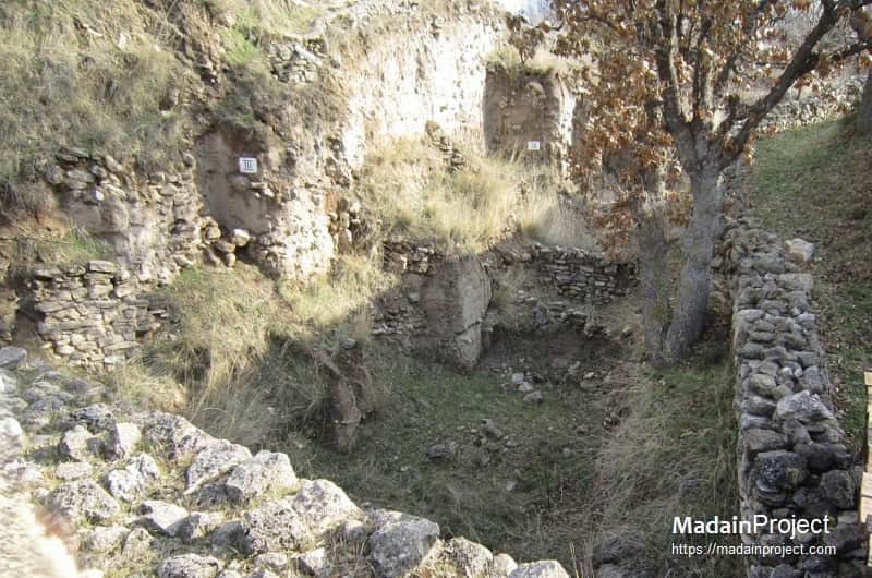
Troy III (circa 2350/2300–2200/2150 BCE) is one of the most poorly preserved phases, as Heinrich Schliemann’s large-scale trenching through the citadel removed most of its deposits without proper documentation. Later excavators recovered only partial remains along the periphery, enough to indicate that the citadel retained elements of Troy II’s fortification wall — massive limestone blocks in cyclopean style — which were reused and perhaps modified with mudbrick superstructures. The occupation appears more densely built than Troy II, with closely packed rectangular houses on stone foundations, arranged without a regular street plan. Pottery is dominated by handmade grey and brown wares, often burnished, with simple incised decoration. A few wheel-made vessels appear, suggesting slow adoption of the technology. Small finds include bone tools, loom weights, and spindle whorls, indicating domestic textile production. There is no definitive evidence for a lower town, though this may be due to Schliemann’s total removal of deposits in those areas.
circa 2200–2000 BCE
Troy IV
Troy IV (circa 2000–1820 BCE) is better documented in surviving areas, showing modest rebuilding within the citadel on a reduced scale. Houses are smaller and more irregularly placed than in Troy II, but some employ interior partitions and built-in features such as benches. The most distinctive innovation of this phase is the appearance of domed clay ovens — permanent installations for baking that represent a technological shift from earlier open hearths. Fortifications from earlier levels seem to have been maintained in a diminished state, with stone socles supporting mudbrick walls. Pottery assemblages are dominated by plain and burnished handmade wares, though some vessels carry combed or incised decoration. A small quantity of imports — including wheel-made Anatolian jars and possibly Cycladic-style marble figurines — point to limited but sustained connections with the wider Aegean-Anatolian interaction sphere.
circa 2000–1750 BCE

Troy V
Troy V (circa 2000–1750 BCE) shows renewed expansion beyond the citadel to the west, where excavations have documented stone foundations of houses that formed a loosely planned lower town. Domestic architecture is more standardized, with rectangular rooms, plastered floors, and both ovens and open hearths. Pottery production is dominated by local handmade wares but includes a distinctive series of “red-cross bowls” — shallow vessels decorated with a red-painted cross motif — which are associated with western Anatolia in this period. Imported Minoan pottery, particularly fineware cups and jars, has been recovered, suggesting intensified trade or exchange networks across the Aegean. Additional imports include obsidian from Melos and possibly metal goods from the Troad hinterland. Small finds such as bronze pins, bone inlays, and faience beads indicate a more diverse material culture than in Troy IV. The absence of monumental public buildings suggests the settlement was a small but well-connected town rather than a major regional center.
circa 1750–1300 BCE
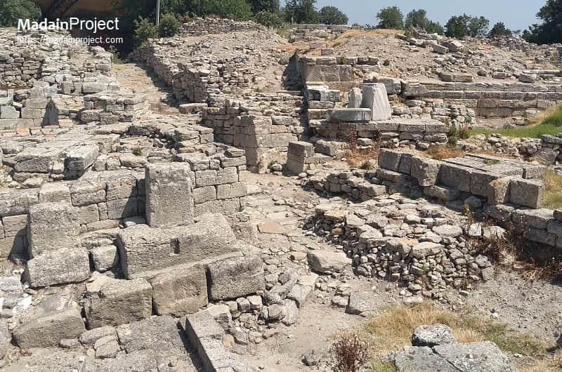
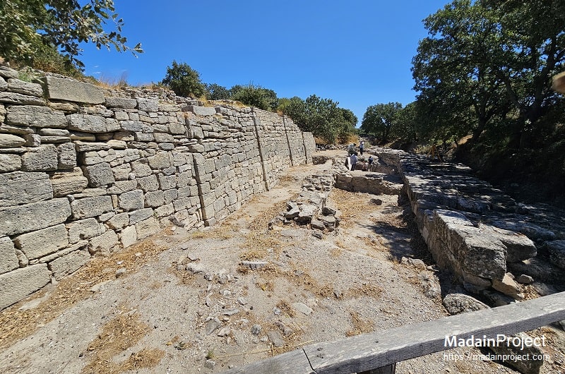
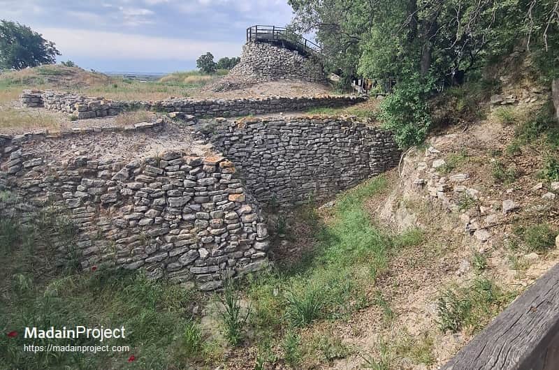
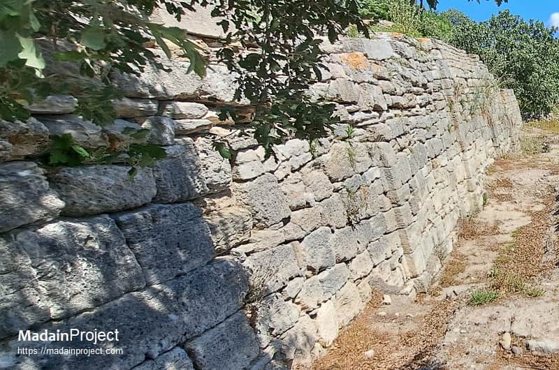
Troy VI
Troy VI (circa 1750–1300 BCE) was a major fortified city whose citadel stood on a series of rising terraces, the outermost still well preserved, lined with freestanding multistory elite houses that blended megaron layouts with irregular plans and showed both local and Aegean influences; a royal palace may have crowned the highest terrace, though later classical construction removed most traces. Its massive limestone ashlar walls, built in a distinctive sawtooth style and sloping like those at Hattusa, expanded over time to 5 m thick and more than 9 m high, punctuated by rectangular watchtowers and five gates, some bearing non-functional pillars interpreted as religious symbols, leading into paved and drained streets.
South of the citadel lay a 30-hectare lower town, defended by a rock-cut ditch and possibly a palisade, with dense neighbourhoods, industrial areas producing goods such as murex-dyed textiles, and agricultural installations; this settlement, only identified in the late 1980s, made Troy VI over sixteen times larger than previously thought. The city’s material culture reflects a distinct northwest Anatolian tradition, centred on wheel-made Tan Ware and Anatolian Gray Ware derived from earlier Minyan traditions, evolving from Aegean to Anatolian forms by 1700 BCE, and supplemented by imported and locally imitated Minoan, Mycenaean, Cypriot, and Levantine wares; notable absences include Hittite artefacts, large-scale sculpture, and wall painting, though horses appear here for the first time.
The spoken language remains unknown, with Luwian considered plausible based on a seal in Anatolian hieroglyphs and indirect Hittite textual references suggesting literacy and a now-lost archive in the citadel’s innermost precinct. The city met its end around 1300 BCE (Troy VIh) in an event most likely caused by an earthquake, evidenced by collapsed masonry and subsidence, though alternative theories include civil unrest or attack, neither supported by signs of burning or casualties.
circa 1300–950 BCE
Troy VII
Troy VIIa, built soon after the destruction of Troy VI around 1300 BCE, appears to have been established by survivors who reused much of the earlier city’s infrastructure, including the citadel walls, which were reinforced with additional stone towers and mudbrick breastworks. The citadel grew crowded with new small houses, while the lower city expanded beyond its earlier extent. Large storage jars (pithoi) buried in floors suggest preparations for siege or stockpiling. Material culture shows continuity with Troy VI, though foreign imports declined. The city met its end circa 1180 BCE, in a destruction layer marked by scorch marks and evidence of enemy attack, placing it in the wider context of the Late Bronze Age collapse.
Troy VIIb, built atop the ruins of VIIa, reused Troy VI’s walls but saw marked cultural shifts over time. The first phase (VIIb1) retained Grey Ware traditions but introduced handmade “barbarian ware” and continued some foreign trade; a unique Luwian-inscribed seal suggests literacy persisted in some form. VIIb2 brought new building styles and knobbed pottery (Buckelkeramik), possibly linked to immigrants from southwest Europe, akin to cultural changes in Phrygian Gordion; it ended in an earthquake around 1050 BCE. VIIb3, dating to the Protogeometric period, left no major new constructions but showed continued pottery production, possible wine or oil trade, and ritual reuse of Troy VI and VIIa structures for worship and communal feasting—seemingly in a ruined state as an intentional link to the past. Troy VIIb was destroyed by fire around 950 BCE, after which occupation persisted only sparsely.
circa 950–85 BCE
Troy VIII
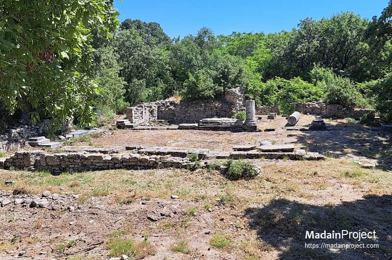
Troy VIII began as a Greek settlement established on the ruins of earlier Troy, most likely by colonists from nearby Greek cities in the Troad. Around 700 BCE, construction resumed on a large scale, with the surviving citadel wall of Troy VI reused as the core defensive perimeter. This fortification not only served a functional purpose during the early Archaic period but also became a cultural landmark, venerated as part of the city’s heroic past. The peak of the citadel, where the palace of Troy VI probably stood, was levelled during Greek building works, erasing a significant portion of the Late Bronze Age remains.
The Archaic and Classical periods saw the development of monumental public architecture, including temples dedicated to Greek deities, a theatre, stoas, and other civic structures. The settlement expanded beyond the citadel, particularly to the south, following the contours of the earlier Bronze Age lower town. Bronze Age remains outside the defensive walls were frequently dismantled for building materials. By the Hellenistic period, Troy VIII had become both a functioning polis and a site of pilgrimage for visitors seeking its legendary associations. It was destroyed in 85 BCE during the First Mithridatic War.
circa 85 BCE- 500 CE
Troy IX
Troy IX was established directly atop the ruins of Troy VIII after its destruction by the Roman general Gaius Flavius Fimbria in 85 BCE. Under Roman control, the city—known as Ilium—received imperial patronage, most notably from Julius Caesar and Augustus, who funded public buildings and infrastructure in recognition of Troy’s mytho-historical importance. The urban plan was reorganized along Roman lines, with a forum, baths, and other facilities integrated into the Hellenistic street grid.
Earthquakes in the late 5th to early 6th century CE caused extensive damage, collapsing many of the major public structures. Rebuilding during the Byzantine period was limited, and much of the city lay in ruins. Nevertheless, archaeological evidence—including Late Byzantine ceramics, small domestic structures, and modifications to earlier buildings—indicates that a reduced population continued to inhabit parts of the citadel and surrounding slopes. By the end of the Byzantine period, the site’s occupation had contracted to scattered, small-scale settlements.
Signup for our monthly newsletter / online magazine.
No spam, we promise.
The Madain Project is an online archive of Abrahamic History and Archaeology.
Abrahamic History & Archaeology is the study of history and archaeology with respect to the three Abrahamic Faiths without considering the religious and theological aspects. The goal of Abrahamic History is to understand how and why the religious doctrines and behaviours have evlovled and changed over time. Searching for patterns in the evolution of significant cultural events such as the development of farming, the emergence of cities, or the collapse of major civilizations for clues of why and how these have influenced the three major Abrahamic religions.
Cloud Drive -
About -
Help -
Editorial Policy -
AI Policy -
Privacy Policy -
Contact
Madain Project: Encyclopedia of Abrahamic History & Archaeology.
Copyright MadainProject 2017 - 2026.
![]()
![]()
![]()
![]()
![]()
![]()